Last updated: August 2026
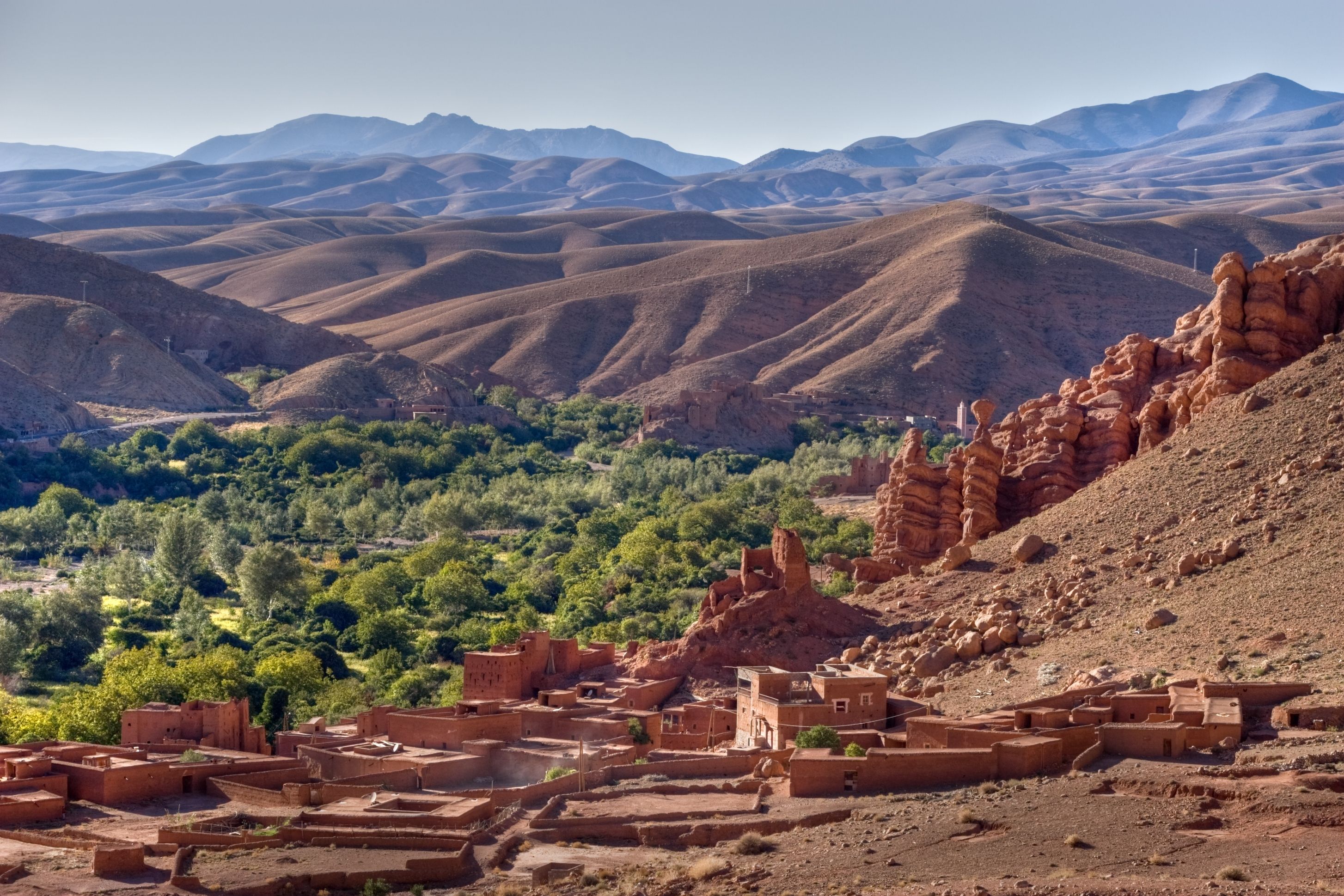
The Dades Valley follows the course of the Dades River between the High Atlas mountains and the more open areas near Boumalne Dades. The landscape brings together cultivated fields, orchards, rock formations, and earthen buildings spread across the slopes and the valley floor.
Boumalne Dades serves as the main access point for anyone arriving via the N10. From the town, the R704 road heads north, follows the valley, and leads to the formations known as Monkey Fingers, the viewpoints, and the Dades Gorge.
The route changes gradually. The first stretches pass through residential and farming areas, while the higher sections reveal rock walls, narrow passages, and sharp bends. It's worth setting aside time to drive the R704 without treating it as mere transit.
The Dades Valley is part of the tourist route known as the Road of a Thousand Kasbahs, which crosses different valleys and oases in southern Morocco. The name isn't a literal count, but it highlights the earthen buildings that mark the region's landscape.
Quick facts
- Visit time: half a day for the main route, or a full day with hikes and several stops
- Location: the Boumalne Dades area, in southern Morocco
- Main access: the N10 to Boumalne Dades and the R704 toward the gorge
- Type of visit: scenic drive, viewpoints, rock formations, and hikes
- Entrance: no general ticket for driving the public roads
- Extra costs: guides, parking, private attractions, and local services are charged separately
- Best time: morning or late afternoon, depending on the season and your schedule
- Accessibility: much of the landscape can be seen by car; hikes involve uneven terrain
- Road: paved on the main tourist route, with bends and conditions subject to weather
Is it worth visiting the Dades Valley?
The Dades Valley is worth visiting for the combination of cultivated land, earthen buildings, and rock formations that change along the R704. It's a different landscape from Morocco's imperial cities, coastline, and better-known dunes.
Anyone traveling between Ouarzazate and Tinghir can use Boumalne Dades as a starting point to explore the valley. With little time, you can head as far as Monkey Fingers and a few viewpoints; with half a day or a full day, the itinerary can include the gorge and a short hike.
What is the Dades Valley?
The Dades Valley is the area formed along the Dades River, which rises in the High Atlas and crosses mountainous landscapes before continuing into more open regions to the south.
Water supports cultivated areas on the valley floor, where there are orchards, small plots, and communities. How much water is visible varies with rainfall, the season, and local use.
The terrain changes along the route. In some spots the valley is relatively wide; in others, the river cuts through narrower rock formations, creating the passages known as the Dades Gorge.
In guides and maps, the name Dades Valley can refer either to the broader geographic region or to the tourist route along the R704 from Boumalne Dades.
Difference between the N10, the R704, and the gorge
The N10 is the main road connecting Ouarzazate, Kelaat M'Gouna, Boumalne Dades, and Tinghir. It runs through the more open part of the region but doesn't cover the famous switchback stretch of the Dades Gorge.
At Boumalne Dades, the R704 branches off from the N10 and heads north. This is the road used to explore the interior of the valley, Monkey Fingers, the switchbacks, the viewpoints, and the gorge.
The Dades Gorge refers to the stretches where the river cuts through narrower passages between the rock formations. It represents one part of the valley, not the whole region.
Anyone traveling directly between Ouarzazate and Tinghir stays on the N10. To see Monkey Fingers, the switchbacks, and the gorge, you need to turn onto the R704 at Boumalne Dades.
How to get to the Dades Valley
Coming from Ouarzazate, head east on the N10, passing through the Kelaat M'Gouna area to Boumalne Dades.
Coming from Tinghir, head west on the N10 to Boumalne Dades. The town is about 50 kilometers from Tinghir, though travel time depends on traffic, roadwork, and stops.
At Boumalne Dades, follow the R704 into the interior of the valley and toward the Dades Gorge.
The main options are:
- Your own or a rented car: offers more flexibility to choose your stops
- A driver or transfer: an alternative for anyone who'd rather not drive the switchbacks
- Taxi: can be arranged in Boumalne Dades, with the price and return trip set in advance
- An organized tour: some itineraries between Ouarzazate, Dades, Todra, and the desert include a pass through the valley
- Bicycle: recommended only for those used to climbs, bends, and road traffic
- A guided hike: an option for exploring trails and formations off the main road
Download the map for offline use and mark Boumalne Dades and the points along the R704 you plan to visit in advance, since the name Dades appears in various accommodations and localities in the region.
How to plan the visit
A practical plan starts in Boumalne Dades and follows the R704. In the first few kilometers, the road passes residential areas, farmland, guesthouses, and earthen buildings; further along, rock formations, hiking access points, and viewpoints appear.
Monkey Fingers and the switchbacks are in different sections. With half a day, choose a few stops and one panoramic point. A full day lets you go further into the gorge, take a short hike, and have lunch in the valley before heading back.
Monkey Fingers
Monkey Fingers is the tourist name for a set of rock formations with rounded shapes and vertical grooves, located near Tamellalt. Prolonged erosion created shapes that, depending on the angle, resemble fingers or paws.
The formations can be seen from the road and also appear along hiking routes. They don't correspond to the R704's famous switchbacks, which are on a different stretch of the Dades Valley.
Road switchbacks and viewpoints
One of the most photographed stretches of the R704 features a sequence of tight switchbacks on the hillside. The panoramic view is usually taken in from elevated points near hotels and restaurants, where access may depend on making a purchase or getting authorization.
Slow down, stay alert to oncoming vehicles, and find a safe spot before stopping to take photos. How the hillsides look changes with the direction of the light and the time of year.
Earthen buildings in the valley
Kasbahs, ksour, houses, and guesthouses are part of the Dades Valley landscape. Many buildings combine earth, stone, and wood with materials added during renovations and adaptations.
A kasbah is usually a fortified residence or a complex tied to a family or authority. A ksar, meanwhile, is a fortified settlement with multiple dwellings and communal spaces.
Some buildings can be visited, while others function as residences, guesthouses, or private property. Check whether the site is open before entering.
Hiking in the Dades Valley
There are hikes near Monkey Fingers, the local communities, and other rock formations in the valley. Routes vary in length and difficulty and can pass over loose rocks, farmland, and unmarked stretches.
Bring water, sun protection, and suitable footwear. For longer routes, consider hiring a local guide. On days with heavy rain, avoid riverbeds and narrow passages because of the risk of a rapid rise in water levels.
Tickets and costs
There's no general ticket for driving the R704 or taking in the Dades Valley from public areas.
Kasbahs open to visitors, parking, private terraces, guides, and other activities may have their own charges. Confirm access and the price in Moroccan dirhams before your visit.
How long to spend
Set aside half a day to leave Boumalne Dades, drive part of the R704, see Monkey Fingers, and stop at a viewpoint. With a full day, you can go further into the gorge and add a short hike.
Entering the Dades Valley means a detour from the N10. It's possible to combine Dades and Todra in the same day with brief stops, but anyone planning to hike or explore both regions unhurried should set aside more time.
Best time to visit
Morning offers milder temperatures and enough time to drive the R704, especially for anyone planning to hike. In the late afternoon, the light can bring out the colors of the hillsides and the earthen buildings.
Start heading back before dark, especially if you're in the higher sections. In summer, avoid hiking during the hottest hours; in winter, bring warm clothing for cold mornings and nights.
Best season to visit
Spring and fall tend to offer more comfortable temperatures for driving and hiking. Summer can be very hot in the open areas, while winter brings cold mornings and nights in the higher sections.
The crops, the amount of water, and the colors of the landscape change throughout the year. During periods of heavy rain, check road conditions before heading up the R704.
Accessibility
Much of the landscape can be seen by car along the R704. Some viewpoints are close to the road, while others involve rocks, dirt, steps, or uneven ground.
Trails near the river generally have uneven terrain and no accessible infrastructure. Anyone who needs an easier stopping point can ask their accommodation or driver to suggest a spot close to the road.
Practical tips
- Fill up the vehicle before heading into the higher sections
- Download the map for offline use
- Turn onto the R704 at Boumalne Dades
- Set aside at least half a day for the drive
- Park off the bends and out of the traffic lane
- Bring water, sun protection, and comfortable shoes
- Agree on the price for guides and transport in advance
- Check the forecast before walking through narrow passages
Final tip
Set out from Boumalne Dades and drive the R704 with enough time to see Monkey Fingers, the switchbacks, and at least one viewpoint. Since these points appear in different stretches, the road reveals new shapes and perspectives as you move through the valley.
Set aside half a day for a scenic drive, or a full day to include the gorge and a hike. That way, the Dades Valley stops being just a detour from the N10 and becomes a complete stage of your route through southern Morocco.